 Terrestrial Impact Craters Terrestrial Impact Craters
Impact craters are geologic structures formed when a large meteorid, asteroid or comet smashes into a planet or a satellite. All the inner bodies in our solar system have been heavily bombarded by meteoroids throughout their history. The surfaces of the Moon, Mars and Mercury, where other geologic processes stopped millions of years ago, record this bombardment clearly. On the Earth, however, which has been even more heavily impacted than the Moon, craters are continually erased by erosion and redeposition as well as by volcanic resurfacing and tectonic activity. Thus only about 120 terrestrial impact craters have been recognized, the majority in geologically stable cratons of North America, Europe and Australia where most exploration has taken place. Spacecraft orbital imagery has helped to identify structures in more remote locations for further investigation.
Meteor Crater (also know as Barringer Crater), Arizona, was the first-recognized terrestrial impact crater. It was identified in the 1920s by workers who discovered fragments of the meteorite impactor within the crater itself. Several other relatively small craters were also found to contain impactor fragments and for many years these remnants were the only accepted evidence for impact origin. However, scientists have come to realize that pieces of the impactor often do not survive the collision intact.
In massive events caused by a large impactor, tremendous pressures and temperatures are generated that may vaporize the meteorite altogether or may completely melt and mix it with melted target rocks. Over several thousand years, any detectable meteoritic component may erode away. In some cases, nonterrestrial relative abundances of siderophile elements can be detected in the impact melt rocks within large craters - a chemical signature of the meteorite impactor.
Since the 1960s, numerous studies have uncovered another physical marker of impact structures, shock metamorphism. Certain shock metamorphic effects have been shown to be uniquely and unambiguously associated with meteorite impact craters; no other earthly mechanism, including volcanism, produces the extremely high pressures that cause them. They include shatter cones, multiple sets of microscopic planar features in quartz and feldspar grains, diaplectic glass, and high-pressure mineral phases such as stishovite. All known terrestrial impact structures exhibit some or all of these shock effects.
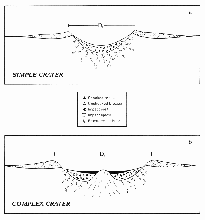
Impact craters are divided into two groups based on morphology: simple craters and complex craters. Simple craters are relatively small with depth-to-diameter ratios of about 1:5 to 1:7 and a smooth bowl shape. In larger craters, however, gravity causes the initially steep crater walls to collapse downward and inward, forming a complex structure with a central peak or peak ring and a shallower depth compared to diameter (1:10 to 1:20). The diameter at which craters become complex depends on the surface gravity of the planet: The greater the gravity, the smaller the diameter that will produce a complex structure. On Earth, this transition diameter is 2 to 4 km (depending on target rock properties); on the Moon, at 1/6 Earth's gravity, the transition diameter is 15 to 20 km.
The central peak or peak ring of the complex crater is formed as the initial (transient) deep crater floor rebounds from the compressional shock of impact. Slumping of the rim further modifies and enlarges the final crater. Complex structures in crystalline rock targets will also contain coherent sheets of impact melt atop the shocked and fragmented rocks of the crater floor. On the geologically inactive lunar surface, this complex crater form will be preserved until subsequent impact events alter it. On Earth, weathering and erosion of the target rocks quickly alter the surface expression of the structure; despite the crater's initial morphology, crater rims and ejecta blankets are quickly eroded and concentric ring structures can be produced or enhanced as weaker rocks of the crater floor are removed. More resistant rocks of the melt sheet may be left as plateaus overlooking the surrounding structure.
Large terrestrial impacts are of greater importance for the geologic history of our planet than the number and size of preserved structures might suggest. For example, recent studies of the Cretaceous/Tertiary boundary, which marks the abrupt demise of a large number of biological species including dinosaurs, revealed unusual enrichments of siderophile elements and shock metamorphic features that are markers of meteorite impact events. Most researchers now believe that a large asteroid or comet hit the Earth at the end of the Cretaceous Period 66 million years ago. An environmental crisis triggered by the gigantic collision contributed to the extinctions. Based on apparent correspondences between periodic variations in the marine extinction record and the impact record, some scientists suggest that large meteorite impacts might be the metronome that sets the cadence of biological evolution on Earth - an unproven but intriguing hypotheses.
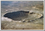
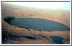
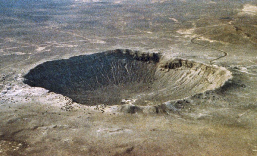
Barringer Meteor Crater, Arizona
(GIF, 308K;
JPG, 107K;
TIF, 2M)
 35°02'N, 111°01'W; diameter: 1.186 km; age: 49,000 years
The origin of this classic simple meteorite impact crater was long the
subject of controversy. The discovery of fragments of the Canyon Diablo
meteorite, including fragments within the
breccia deposits that partially
fill the structure, and a range of shock metamorphic features in the
target sandstone proved its impact origin. Target rocks include
Paleozoic
carbonates and sandstones; these rocks have been overturned just outside
the rim during ejection. The hummocky deposits just beyond the rim are
remnants of the ejecta blanket. This aerial view shows the dramatic
expression of the crater in the arid landscape.
(Courtesy of D. Roddy)
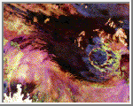
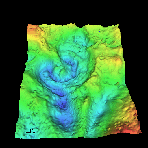
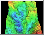 Chicxulub, Yucatan Peninsula, Mexico
(GIF, 104K)
Chicxulub, Yucatan Peninsula, Mexico
(GIF, 104K)
21°20'N, 89°30'W; diameter: 300 km; age: 64.98 million years
This three-dimensional map of local gravity and
magnetic field variations shows a multiringed structure called
Chicxulub named after a village located near its center.
The impact basin is buried by several hundred meters of sediment
making it hidden from view.
This image shows the basin viewed obliquely from approximately 60 degrees
above the surface looking north, with artificial lighting from the south.
The image covers 88 to 90.5 degrees west longitude and 19.5 to 22.5 degrees
north latitude. NASA scientists believe that an asteroid 10 to 20 km
in diameter produced this impact basin. The asteroid hit a
geologically unique, sulfur-rich region of the Yucatan Peninsula which
kicked up billions of tons of sulfur and other materials into the
atmosphere. Darkness prevailed for about half a year after the collision.
This caused temperatures to globally plunged near freezing. Half
of the species on Earth became extinct including the dinosaurs.
(Courtesy of Virgil L. Sharpton)
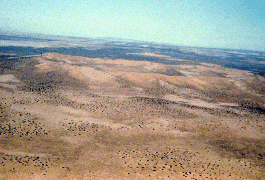
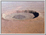 Wolfe Creek, Australia
(GIF, 199K)
Wolfe Creek, Australia
(GIF, 199K)
19°18'S, 127°46'E; rim diameter: 0.875 km; age: 300,000 years
Wolfe Creek is a relatively well-preserved crater that is partly buried
under wind blown sand. The crater is situated in the flat desert plains
of north-central Australia. Its crater rim rises ~25 m above the
surrounding plains and the crater floor is ~50 m below the rim. Oxidized
remnants of iron meteoritic material as well as some impact glass have
been found a Wolf Creek. This photograph is a south-looking, oblique
aerial view of the crater.
(Courtesy of V. L. Sharpton)
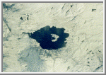
 Lonar, India
(GIF, 246K)
Lonar, India
(GIF, 246K)
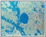
19°59'N, 76°31'E; rim diameter: 1.830 km; age: 52,000 years
Lonar Crater is an almost circular depression in the
basaltic flows of the
Deccan Traps in southern India. It is nearly 150 m deep and a shallow
saline lake occupies most of the crater interior and covers about 100 m of
sedimentary fill. The crater rim is elevated about 20 m above the
surrounding plain. The ejecta layer is partially preserved and contains
minerals and rocks displaying all degrees of shock metamorphism,
confirming the impact origin of the crater. This is the only known crater
on Earth in a basaltic target and thus provides valuable insight into
lunar cratering. The photo shows an oblique aerial view of the structure.
(Courtesy of A. V. Murali)
Roter Kamm, South West Africa/Namibia
(GIF, 438K)
27°46'S, 16°18'E; rim diameter: 2.5 km; age: 5 +- 0.3 million years
Located in the Namibia Desert, the raised crater rim is clearly visible
against darker background vegetation. Target rocks include primarily
Precambrian crystalline rocks and modest
amounts of younger sedimentary rocks. Outcrops of impact melt breccias
are found exclusively on the crater rim. The crater floor is covered by
broad, shifting sand dunes. This image shows an oblique view of the
crater, from about 150 m above ground looking southeast.
(Courtesy of W. U. Reimold)
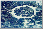
 Roter Kamm, SAR-C/X-SAR Image
(GIF, 213K)
Roter Kamm, SAR-C/X-SAR Image
(GIF, 213K)
This space radar image shows the Roter Kamm impact crater.
The crater rim is seen as a radar-bright, circular feature.
The bright white irregular feature in the lower left
corner is a small hill of exposed rock outcrop. Roter Kamm
is a moderate sized impact crater, 2.5 kilometers
in diameter, and is 130 meters deep. However, its original floor is
covered by sand deposits at least 100 meters thick. In a
conventional aerial photograph, the brightly colored
surfaces immediately surrounding the crater cannot be seen
because they are covered by sand. The faint blue surfaces
adjacent to the rim may indicate the presence of a layer of
rocks ejected from the crater during the impact. The
darkest areas are thick windblown sand deposits which form
dunes and sand sheets. The sand surface is smooth relative
to the surrounding granite and limestone rock outcrops and
appears dark in radar image. The green tones are related
primarily to larger vegetation growing on sand soil, and the
reddish tones are associated with thinly mantled limestone
outcrops.
(Courtesy NASA/JPL)
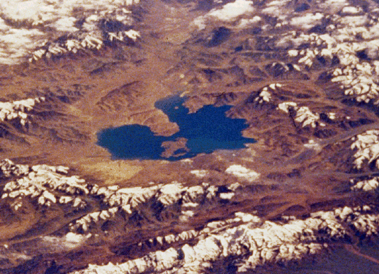
 Mistastin Lake, Newfoundland and Labrador, Canada
(GIF, 393K)
Mistastin Lake, Newfoundland and Labrador, Canada
(GIF, 393K)
55°53'N, 63°18'W; rim diameter: 28 km; age: 38 +- 4 million years
This shuttle image shows a winter view of the Mistastin Crater, a heavily
eroded complex structure. Eastward moving glaciers have drastically
reduced the surface expression of this structure, removing most of the
impact melt sheet and breccias and exposing the crater floor. Glacial
erosion has also imparted an eastward elongation to the crater that is
particularly evident in the shape of the lake that occupies the central
10 km of the structure. Horseshoe Island, in the center of the lake, is
part of the central uplift and contains shocked Precambrian crystalline
target rocks. Just beyond the margins of the lake are vestiges of the
impact melt sheet that contains evidence of meteoritic features in
quartz, feldspar and diaplectic glasses.
(Courtesy NASA)
 Manicouagan, Quebec, Canada
(GIF, 313K)
Manicouagan, Quebec, Canada
(GIF, 313K)
51°23'N, 68°42'W; rim diameter: ~100 km; age: 212 +- 1 million years
The Manicouagan impact structure is one of the largest impact craters still
preserved on the surface of the Earth. This shuttle view
shows the prominent 70 km diameter, ice-covered annular lake that
fills a ring where impact-brecciated rock has been eroded by glaciation.
The lake surrounds the more erosion-resistant melt sheet created by impact
into metamorphic and igneous
rock types. Shock metamorphic effects are
abundant in the target rocks of the crater floor. Although the original
rim has been removed, the distribution of shock metamorphic effects and
morphological comparisons with other impact structures indicates an
original rim diameter of approximately 100 km.
(Courtesy NASA)
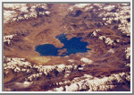
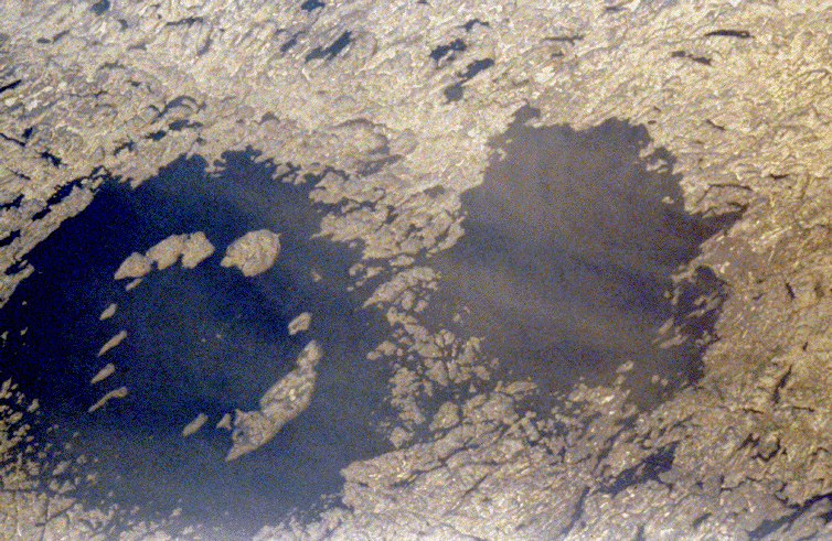
![]() Clearwater Lakes, Quebec, Canada
(GIF, 316K)
Clearwater Lakes, Quebec, Canada
(GIF, 316K)
Clearwater Lake West: 56°13'N, 74°30'W; rim diameter: 32 km
Clearwater Lake East: 56°05'N, 74°07'W; rim diameter: 22 km
age: 290 +- 20 million years
Twin impact craters, which are formed simultaneously by two separate but
probably related meteorite impacts, are very rarely recognized on Earth.
This pair is situated in crystalline bedrocks of the Canadian
shield. The larger Clearwater Lake
West (left) shows a prominent ring of islands that has a diameter of about
10 km. They constitute a central uplifted area and are covered with
impact melts. The central peak of the smaller Clearwater Lake East (right)
is submerged.
(Courtesy NASA)
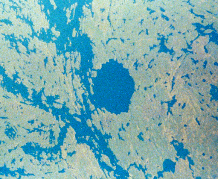
 Deep Bay, Saskatchewan, Canada
(GIF, 453K)
Deep Bay, Saskatchewan, Canada
(GIF, 453K)
56°24'N, 102°59'W; rim diameter: 13 km; age: 100 +- 50 million years
This crater consists of a near-circular bay, about 5 km wide and 220 m
deep, in the otherwise shallow Reindeer Lake. Such deep circular lakes are unusual in this region, which is dominated by the shallow gouging of glacial
erosion. The circular shoreline, at a diameter of 11 km, is partially
surrounded by a ridge with heights to 100 m above the lake surface. The
diameter of this ridge, ~13 km, is likely the outer rim of the impact
structure. The structure was formed in Precambrian metamorphic crystalline
rocks with a conspicuous northwest trending fabric. Although not obvious
from the surface, Deep Bay is a complex impact structure with a low,
totally submerged central uplift. Samples obtained in the 1960s from
drilling into the central structure revealed shocked and fractured
metamorphic rocks flanked by deposits of
allocthonous, mixed breccias.
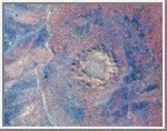
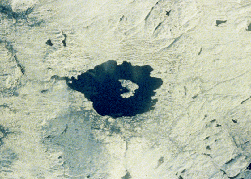
 Bosumtwi, Ghana
(GIF, 328K)
Bosumtwi, Ghana
(GIF, 328K)
06°32'N, 01°25'W; rim diameter: 10.5 km; age: 1.3 +- 0.2 million years
This crater is situated in crystalline bedrocks of the West African Shield
and is filled almost entirely by Lake Bosumtwi. Chemical, isotopic, and
age studies demonstrate that the crater is the most probable source for the
Ivory Coast tektites, which are found on
land in the Ivory Coast region of central Africa and as microtektites in
nearby ocean sediments. In this photo the crater lake is partly obscured
by clouds.
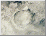
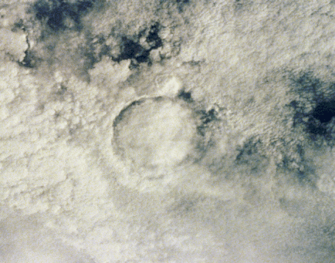
 Gosses Bluff, Northern Territory, Australia
(GIF, 413K)
Gosses Bluff, Northern Territory, Australia
(GIF, 413K)
23°50'S, 132°19'E; rim diameter: 22 km; age: 142.5 +- 0.5 million years
This highly eroded structures is situated just south of the MacDonnell
Ranges (top of picture) in the arid Missionary Plain in the Northern
Territories, Australia. Although it could be mistaken for the crater rim,
the central ring of hills (5 km diameter) results from differential
erosion of the central uplift within this large complex crater. The rim
itself has been eroded and is no longer visible, but the circular, grayish
colored drainage system outside the inner ring of hills probably marks the
original extent of the structure before erosion.
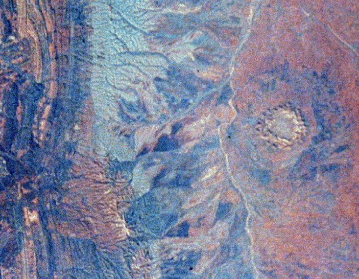
 Kara-Kul, U.S.S.R.
(GIF, 413K)
Kara-Kul, U.S.S.R.
(GIF, 413K)
38°57'N, 73°24'E; rim diameter: 45 km; age: <10 million years
The spectacular Kara-Kul structure is readily apparent in this oblique view.
Partly filled by the 25-km-diameter Kara-Kul Lake, it is located at almost
6000 m above sea level in the Pamir Mountain Range near the Afghan border.
Only recently have impact shock features been found in local
breccias and
cataclastic rocks.
The information on this page was taken primarily from Koeberl and Sharpton.
Koeberl, Chritian and Virgil L. Sharpton. Terrestrial Impact Craters Slide Set. Lunar and Planetary Institute.
Pilkington, M. and R. A. F. Grieve, "The Geophysical Signature of Terrestrial Impact Craters." Reviews of Geophysics, May 1992, vol. 30, pp. 161-181.

 Earth
Earth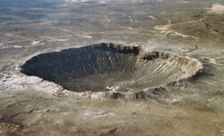