
 Mount
Ipf
Mount
Ipf
 Protected Monument
Prehistoric settlement and Celtic hillfort
near Bopfingen, Ostalbkreis, Baden-Wuerttemberg/Germany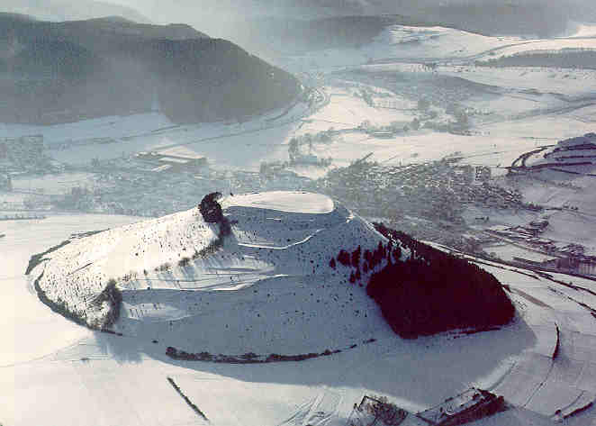
 Ramparts
at Mount Ipf
Ramparts
at Mount Ipf - Late Bronze Age (Urnfield Culture) 12th - 9th century BC
- Iron Age (Hallstatt Culture) 8th - 5th century BC
- Princely Hillfort
- Celtic Period (Latène Period) 5th - 3rd century BC
The Ipf is an isolated projection of the high plateau of the Suabian Alb in the southwest of the Ries meteoric impact crater. From the west its markedly bare character can be seen. Indeed, its giant size dominates the neighbourhood in the crater's basin.
The fortifications
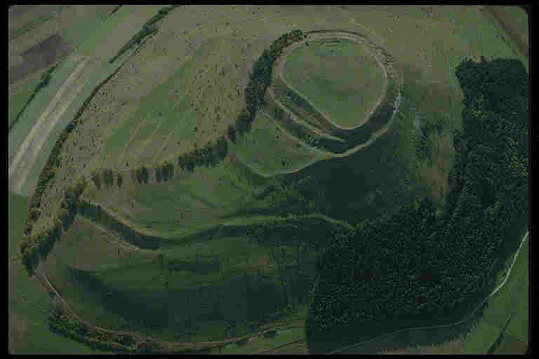
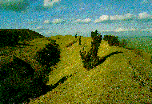
It has on its top a system of mighty ramparts from prehistoric times. The oval summit (with a diameter of 180 m) is encircled by a stone rampart. Outside this rampart a great ditch is cut deeply into the rock. The debris from this has been used to build a second, an outer wall around the first. To the east the flat slope has been strongly fortified: between the two ramparts which encircle the summit, a third has been inserted. A fourth rampart, curving around in a great half circle, gives even greater security.
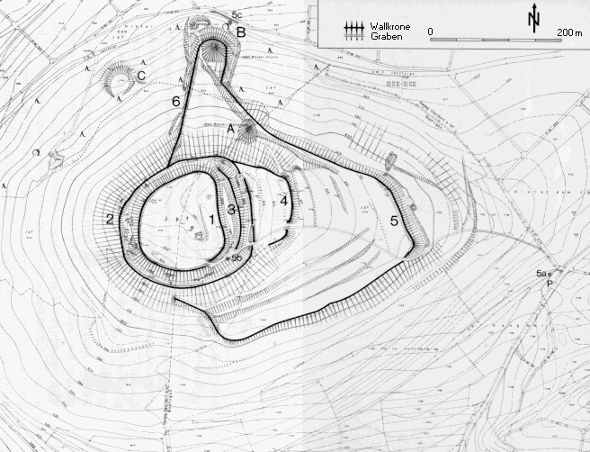 Map of
Mount Ipf (83 KB GIF)
Map of
Mount Ipf (83 KB GIF)On the northern side of the hill three declivities can be seen: the lowest "Der Kessel" (The Cauldron), at the foot of the hill, a little to the east "Die Pfanne" (The Pan), while "Der Löffel" (The Spoon) is slightly more to the east and halfway down the slope. Above these are the remains of ramparts which are tied in with the main fortifications. Another great rampart describes a curve around the hill on the eastern and southeastern flanks. On the northern part a huge rampart with outer ditch turns in toward the southeast, interrupted by a gate. Beyond this gate, noticeable only as a mere terrace step, the rampart takes a sharp bend in the middle of the southern slope. Another gate way with the wall ends turned in at right angles may have stood here. After rising steeply, the rampart reaches the upper circle. The old ascent runs up the eastern slope through the gate mentioned above. It cuts through the four uppermost ramparts rising to the summit by a huge ramp in the southeast corner.
 ramparts
at the summit (80KB GIF)
ramparts
at the summit (80KB GIF)
Probably the four ramparts at the top, including those which fortified and secured the sources of water, were built during Hallstatt times (the perimeter wall perhaps already in Urnfield times). The great lower rampart, with possibly two gates, may have been built in Late Celtic times. Extensions during the Middle Ages have also been suggested.
The cemetery
The cemetery of the Ipf people is likely to be the great group of grave barrows near Hof Meisterstall, about 1.5 km northwest of the hill.
Traditions
The prehistoric, probably Illyrian, name of the stronghold was "Opie" . This became the name of the Roman fort and vicus (end of 1st century - 1st part of 3rd century A.D.) , today Oberdorf, at the foot on the west side of the hill. The present-day name "Ipf" is clearly derived from this.
A Spring Festival held from the Middle Ages until the end of the 18th century is linked with the prehistoric significance of the Ipf. The Ipf Fair of the 19th century only began after 1800.
Excavations
Excavations were carried out in 1907 and 1908. They showed that the lower rampart was broad and faced with dry-stone walling with vertical timber posts. There was timber-strengthened dry-stone walling in the upper rampart face. Buried timbers which reinforced the upper perimeter rampart, which was about 5 m in breadth, were detected. Within the summit area a considerable accumulation was found containing prehistoric hut floors, objects of Neolithic and, a few, of Bronze Age origin. Lots of finds are from Late Urnfield, Middle and Late Hallstatt period (among them a fragment of a Late Hallstatt glass vessel). A few things belong to Early La Tène age. Late La Tène was not present.
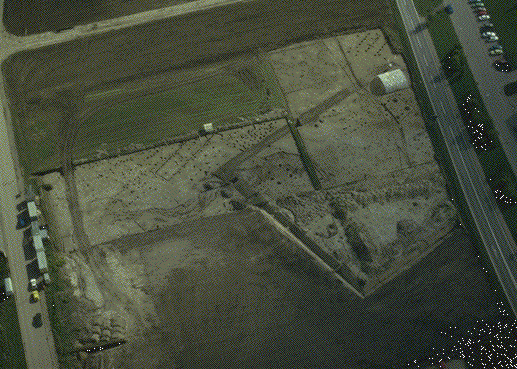
In 1989 - 1992 a Celtic settlement and a rectangular earthwork enclosure ( "Viereckschanze" dated 3rd-2nd century B.C. ) (Aerial view: 80KB GIF) was excavated in the valley of the Eger south to the Ipf.
The relation of this settlement to the fortifications on Mount Ipf must be investigated in future times.
Readings (in German only):
Rüdiger Krause
Vom Ipf zum Goldberg: Archäologische
Wanderungen am Westrand des Ries. Führer zu archäologischen
Denkmälern in Baden-Württemberg, Vol. 16 (1992).
Publ.:
Konrad Theiss Verlag, Stuttgart 1992. - ISBN 3-8062-1020-9
Rüdiger Krause and Günther Wieland
Eine
keltische Viereckschanze bei Bopfingen am Westrand des Rieses. Germania
71, 1993, 59-112.
Aerial photos by Otto Braasch
If you have any comments or questions, please contact me: Wolfgang M. Werner wmwerner@compuserve.com
- Last update: 3 Dec. 1995 -