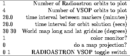
Table 2: Ground.par file
Default values and input parameters that control the execution of the program are specified in the ground.par parameter file. The content of this file and the order in which entries must appear are shown in Table 2.
The first line in Table 2 contains the initial values for the semi-major axis, eccentricity, inclination, longitude of ascending node, argument of perigee and mean anomaly. Here, the semi-major axis must be in meters. The next two lines contain the date and universal time of the orbital ascending node corresponding to the specified orbital elements. These allow the user to update the orbital elements and epoch for which they are valid.
The fourth line contains the number of orbits for which the user wishes the ground tracks to be calculated and the fifth line contains the time interval between calculations in minutes. The following line contains the elevation limit of the telemetry stations; i.e., the telemetry stations can only establish contact with the satellite if the satellite is further above the horizon than this limit. Finally, the last line sets the colour toggle default. Setting this parameter to zero will display the portions of the ground tracks during which the satellite is not visible from any available telemetry ground station in red. In order to change this so that these portions of the ground tracks are not plotted, this value should be set to 1.